Update:  As documented in this letter, Caltrain has reached agreement with the City of San Jose on changes to the bridge construction that will facilitate the city constructing the trail, and is working with the city to reach agreement on costs.  However, local trail advocates continue to be concerned that the trail, a major commute route, would be unusable for much of the winter.  And there remains a risk that the new bridge will be incompatible with High Speed Rail and could need to be rebuilt shortly after this $20million construction project.
The Los Gatos Creek Trail, a commute and recreational route from Los Gatos and Campbell into San Jose Diridon, could be under water through much of the winter, if Caltrain goes through with changed plans for a replacement bridge. Â And brand new High Speed Rail plans could cause the bridge to be obsolete in less than a decade.
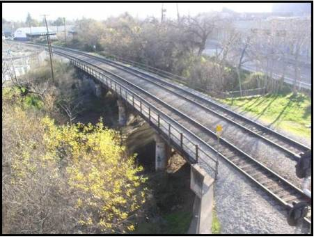
The bridge was built in 1935 and isn’t earthquake-safe so it needs replacing.  Caltrain has recently sent sent the project out to bid.
However, recent changes to the Los Gatos Bridge replacement project would force the Los Gatos Creek Trail even lower than was disclosed in its environmental review document.  This would result in the trail being closed for 14 days in a typical winter, and unusable for about 40 days, according to local trail advocates, who observe that the city takes time to clean up trails after flooding to make them usable again.  In addition, Caltrain disclosed that the retaining wall for the bridge won’t be deep enough for the trail, and that they expect the City of San Jose to pick up the cost to extend the wall to protect the trail.
The various changes could make it infeasible or much more costly for San Jose to build the trail. The City of San Jose has sent a letter to Caltrain asking for changes in the bridge design to ensure that the trail is feasible. Â Â
To make matters worse, High Speed Rail’s new proposal to approach Diridon at grade would require adding a 3rd surface track for freight under the bridge, making it even more challenging to preserve a working trail.  High Speed Rail expects to make a decision about its approach to Diridon over the next year.
The Los Gatos and Guadalupe Creek Trails are part of San Jose’s plans to achieve 15% bicycle mode share per the 2040 General Plan, and are logically important for Caltrain’s goals to increase biking and walking mode share to Diridon Station. Nobody would even think of building a road connecting to a train station in a way that it would be under water much of the winter!    And High Speed Rail’s new plans could make this bridge obsolete in less than a decade.
Caltrain should retract the call for bids, coordinate with High Speed Rail on the specifications that will be needed to accommodate High Speed trains a decade from now. Â Then, the project should be re-issued with a design that will preserve a functioning trail, and support the passage of High Speed trains.
If you want to make sure that the Los Gatos Creek trail serve commuters and recreational cyclists all year long, and that the trail will work when high speed rail arrives:
* send a note to the Caltrain board, board@caltrain.com, the project team, lgcbridge@caltrain.com, and the HSR planning team, san.francisco_san.jose@hsr.ca.gov. Feel free to copy us at friends@friendsofcaltrain.com
* sign up to support access to the stations you use in San Jose (if you use stations south of Tamien, say so in the comment field)
* if you can make Thursday morning’s board meeting in San Carlos at 10am, come then


If going under the tracks is or will be impossible, or too expensive, why not consider a bike/pedestrian bridge over the tracks.
http://www.caltrain.com/Assets/_Public+Affairs/Government+Affairs/doc/Community+Meeting+PowerPoint+Presentation+LG.pdf
If you look at slide 16, I think you’ll see what the issue is. The tracks are running at grade, and creek is rather shallow. If that’s the case, there simply isn’t enough clearance for a trail to dip low enough with bikers hitting their heads while also providing support for the rails.
In other situations like that, it’s easy to arch the roadway for more clearance. Also, the lighter weight of materials and vehicles allow for a thinner bridge.
It’s not possible to raise the track since there’s an overpass for W San Carlos St. right next to the creek.
This is a 20 million dollar project, but if you need to rebuild San Carlos St overpass and the trail and the same time, it’s turning into a 100 million project that’s also tied with Auzerais grade separation.
Tough call. Might worth doing this, since this work is minimal in scope and cost.
If you look at slide 18, you can see where they want to build the third tracks (in the middle of the creek!!!)
This is why we asked them repeatedly to move the third track to the other (east) side (behind OSH)
Replacing the overpass is not an issue because the overpass needs replacing BEFORE the new bridge because the overpass (unlike the bridge) has never been retrofitted.
Roland… I found this answer as why the track is going on the West side:
“The potential alignment of the tail track on the east side would conflict with the bridge abutments
for the West San Carlos Street overpass. East of the mainline tracks is a threeâ€column pier, parallel
to the Los Gatos Creek, supporting the West San Carlos Street overpass. This pier is in direct
conflict with an east shoofly/tail track alignment. However, west of the mainline tracks, the West
San Carlos Street overpass piers are parallel to the mainline track alignments. Due to the pier
configurations, the shoofly must be located west of the mainline tracks to avoid the need to alter the
San Carlos Street overpass. Although the City of San Jose intends to replace the West San Carlos
Street overpass, the project is in its very early planning stages and will be completed after the
completion of the Los Gatos Creek Bridge Replacement.”
Also… look at this picture from Google Street View:
https://goo.gl/maps/xTMTqmEWXHQ2
If the track is placed on the eastern side, there’s no room since the San Carlos bridge abutments switch from running parallel to the tracks to diagonal from the tracks preventing squeezing in a track there.
This photos might not do it justice, but it’s starting to sound like you’d want to include San Carlos bridge replacement along with this project.
Caltrain would prefer to decouple them as much as possible.
The June 2014 Google Maps Streetview shows it from the best angle. Roland, contrary to your assertion that the overpass has never been retrofit, one can clearly see the cables added to tie the top of the supports and the overpass together. This type of retrofit was common all over the state following the 1989 Loma Prieta quake.
Well, look on the brightside… When HSR construction begins, the city of San Jose will finally be ready to rebuild this overpass such that we can fit 4 tracks easily. Then you’ll have your track on the other side. 🙂
The VTA had the exact same problem with the Vasona line on the other side of the overpass. Here is how they took care of the problem (they replaced the conflicting bent):
https://www.google.com/maps/@37.3238998,-121.9032382,3a,90y,15.57h,87.39t/data=!3m6!1e1!3m4!1sIbENK0LdwediLVh2Chz9dg!2e0!7i13312!8i6656
Yep. VTA definitely did something there. Perhaps they had no other option. I wonder how much such a change costs.
Then again, if Caltrain were to make changes to the bridge, we’d find some other people complaining about wasting money on a bridge that’s about to be replaced anyway.